QUESTION IMAGE
Question
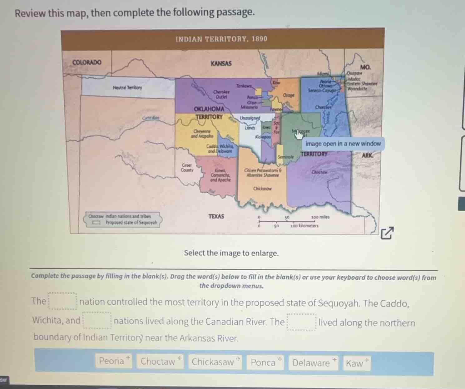
review this map, then complete the following passage.
indian territory. 1890
colorado kansas mo.
neutral territory
quapaw
modoc
eastern shawnee
wyandotte
cherokee
outler
otoe-
missouria
ottawa
oklahoma
territory
unassigned
land
seminole
territory
ark.
caddo, wichita,
and delaware
creek
county
kiowa,
comanche,
and apache
creek freedmens &
absentee shawnee
chickasaw
choctaw indian nations and tribes
proposed state of sequoyah
texas
0 50 100 miles
0 50 100 kilometers
select the image to enlarge.
complete the passage by filling in the blank(s). drag the word(s) below to fill in the blank(s) or use your keyboard to choose word(s) from
the dropdown menus.
the nation controlled the most territory in the proposed state of sequoyah. the caddo,
wichita, and nations lived along the canadian river. the lived along the northern
boundary of indian territory near the arkansas river.
peoria choctaw chickasaw ponca delaware kaw
To solve this, we analyze the map and the options:
- For the first blank: The Choctaw nation had a large territory in the proposed Sequoyah state (from the map’s legend and territory distribution).
- For the second blank: The Caddo, Wichita, and Delaware nations are grouped together along the Canadian River (per the map’s labels).
- For the third blank: The Kaw (or Kanza) lived near the northern boundary by the Arkansas River (matching the map’s northern region labels).
- First blank: The Choctaw nation’s territory is the largest in the proposed Sequoyah state (from the map’s “Choctaw” labeled region).
- Second blank: The Caddo, Wichita, and Delaware nations are associated with the same region along the Canadian River (map labels).
- Third blank: The Kaw (Kanza) is located near the northern boundary by the Arkansas River (map’s northern area).

Snap & solve any problem in the app
Get step-by-step solutions on Sovi AI
Photo-based solutions with guided steps
Explore more problems and detailed explanations
- Choctaw
- Delaware
- Kaw
(Note: The first blank uses "Choctaw", the second "Delaware", the third "Kaw" to match the map’s territorial and river - adjacent distributions.)