QUESTION IMAGE
Question
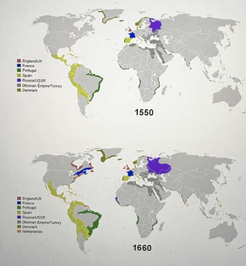
two world maps labeled 1550 and 1660, showing the territories of different countries/empires (england/uk, france, portugal, spain, russia/ussr, ottoman empire/turkey, denmark, and netherlands in 1660) with different colored regions. the 1550 map has regions colored for england/uk, france, portugal, spain, russia/ussr, ottoman empire/turkey, denmark. the 1660 map adds netherlands and has some territorial changes in the colored regions compared to 1550.
To analyze this problem, we focus on the changes in the territorial claims or colonial holdings of different countries between 1550 and 1660 as shown on the world maps.
Step 1: Identify the countries and their regions in 1550
- England/UK: Limited presence (maybe in parts of Europe).
- France: Some presence in Europe.
- Portugal: Colonial regions in South America (green - hued areas).
- Spain: Colonial regions in the Americas (yellow - hued areas).
- Russia/USSR: Presence in parts of Europe and Asia (purple - hued areas).
- Ottoman Empire/Turkey: Presence in the Middle East and parts of Europe (gray - hued areas).
- Denmark: Some presence in Europe and maybe other regions (greenish - gray hued areas).
Step 2: Identify the changes by 1660
- England/UK: Expanded in North America (new red - hued areas).
- France: Expanded in North America (new blue - hued areas) and maybe other regions.
- Portugal: Adjusted its colonial regions in South America (the green - hued areas changed).
- Spain: Adjusted its colonial regions in the Americas (the yellow - hued areas changed).
- Russia/USSR: Expanded in Europe and Asia (the purple - hued areas grew).
- Ottoman Empire/Turkey: Maintained or adjusted its presence in the Middle East and Europe.
- Denmark: Maintained or adjusted its presence.
- Netherlands: New presence (new brown - hued areas, likely in colonial regions).
If we were to answer a specific question like "Which country expanded its colonial holdings in North America between 1550 and 1660?"
Looking at the maps, England/UK (red - hued areas) and France (blue - hued areas) show new colonial holdings in North America by 1660 compared to 1550. England/UK has expanded in North America with new red - colored regions, and France has new blue - colored regions in North America.

Snap & solve any problem in the app
Get step-by-step solutions on Sovi AI
Photo-based solutions with guided steps
Explore more problems and detailed explanations
England/UK and France (England/UK expanded its colonial holdings in North America with new red - hued regions; France expanded its colonial holdings in North America with new blue - hued regions)