QUESTION IMAGE
Question
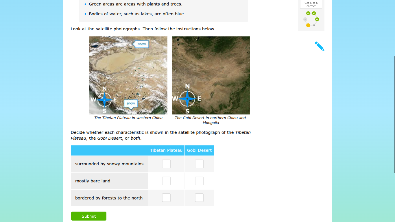
- green areas are areas with plants and trees.
- bodies of water, such as lakes, are often blue.
look at the satellite photographs. then follow the instructions below.
the tibetan plateau in western china the gobi desert in northern china and mongolia
decide whether each characteristic is shown in the satellite photograph of the tibetan plateau, the gobi desert, or both.
tibetan plateau gobi desert
surrounded by snowy mountains
mostly bare land
bordered by forests to the north
submit
To solve this, we analyze each characteristic using the satellite photos:
1. “surrounded by snowy mountains”
- Tibetan Plateau: The photo shows snow - labeled areas around it (mountains with snow). So check the box for Tibetan Plateau.
- Gobi Desert: The Gobi Desert photo has no visible snowy mountain surrounds. So leave Gobi Desert’s box unchecked.
2. “mostly bare land”
- Tibetan Plateau: The photo shows large areas of bare - looking terrain (along with snow - covered regions). So check its box.
- Gobi Desert: The Gobi Desert photo is predominantly bare, arid land. So check its box.
3. “bordered by forests to the north”
- Tibetan Plateau: The photo doesn’t show forested borders to the north. Leave its box unchecked.
- Gobi Desert: The Gobi Desert photo shows green (forested - like) areas to the north. So check its box.
Final Checkboxes (from top to bottom, left to right: Tibetan Plateau, Gobi Desert)
- surrounded by snowy mountains: $\boldsymbol{\checkmark}$ (Tibetan Plateau), $\boldsymbol{\square}$ (Gobi Desert)
- mostly bare land: $\boldsymbol{\checkmark}$ (Tibetan Plateau), $\boldsymbol{\checkmark}$ (Gobi Desert)
- bordered by forests to the north: $\boldsymbol{\square}$ (Tibetan Plateau), $\boldsymbol{\checkmark}$ (Gobi Desert)
After marking, click “Submit” to finish.

Snap & solve any problem in the app
Get step-by-step solutions on Sovi AI
Photo-based solutions with guided steps
Explore more problems and detailed explanations
To solve this, we analyze each characteristic using the satellite photos:
1. “surrounded by snowy mountains”
- Tibetan Plateau: The photo shows snow - labeled areas around it (mountains with snow). So check the box for Tibetan Plateau.
- Gobi Desert: The Gobi Desert photo has no visible snowy mountain surrounds. So leave Gobi Desert’s box unchecked.
2. “mostly bare land”
- Tibetan Plateau: The photo shows large areas of bare - looking terrain (along with snow - covered regions). So check its box.
- Gobi Desert: The Gobi Desert photo is predominantly bare, arid land. So check its box.
3. “bordered by forests to the north”
- Tibetan Plateau: The photo doesn’t show forested borders to the north. Leave its box unchecked.
- Gobi Desert: The Gobi Desert photo shows green (forested - like) areas to the north. So check its box.
Final Checkboxes (from top to bottom, left to right: Tibetan Plateau, Gobi Desert)
- surrounded by snowy mountains: $\boldsymbol{\checkmark}$ (Tibetan Plateau), $\boldsymbol{\square}$ (Gobi Desert)
- mostly bare land: $\boldsymbol{\checkmark}$ (Tibetan Plateau), $\boldsymbol{\checkmark}$ (Gobi Desert)
- bordered by forests to the north: $\boldsymbol{\square}$ (Tibetan Plateau), $\boldsymbol{\checkmark}$ (Gobi Desert)
After marking, click “Submit” to finish.