QUESTION IMAGE
Question
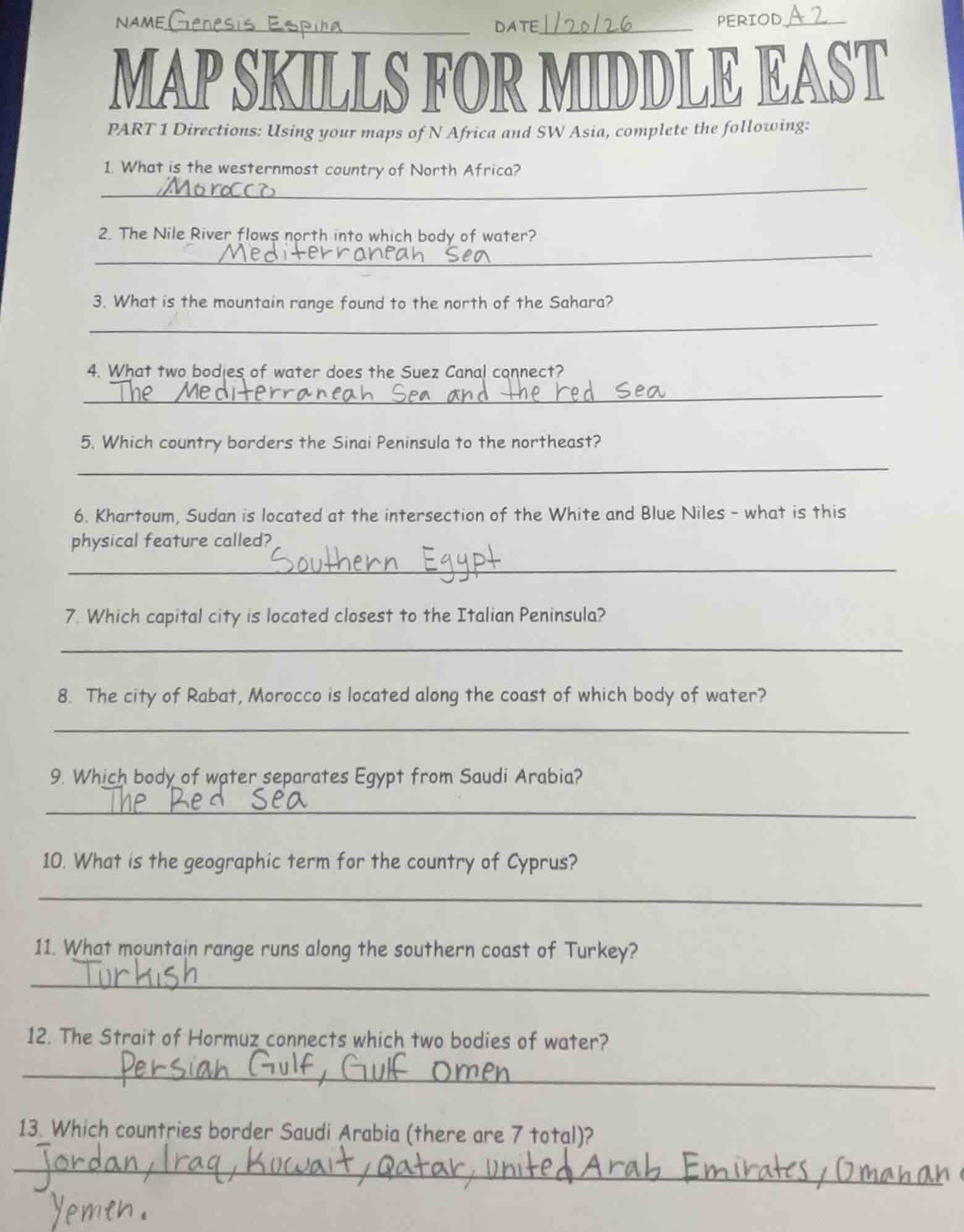
name genesis espina date 1/20/26 period a2
map skills for middle east
part 1 directions: using your maps of n africa and sw asia, complete the following:
- what is the westernmost country of north africa?
morocco
- the nile river flows north into which body of water?
mediterranean sea
- what is the mountain range found to the north of the sahara?
- what two bodies of water does the suez canal connect?
the mediterranean sea and the red sea
- which country borders the sinai peninsula to the northeast?
- khartoum, sudan is located at the intersection of the white and blue niles - what is this physical feature called?
southern egypt
- which capital city is located closest to the italian peninsula?
- the city of rabat, morocco is located along the coast of which body of water?
- which body of water separates egypt from saudi arabia?
the red sea
- what is the geographic term for the country of cyprus?
- what mountain range runs along the southern coast of turkey?
turkish
- the strait of hormuz connects which two bodies of water?
persian gulf, gulf omen
- which countries border saudi arabia (there are 7 total)?
jordan, iraq, kuwait, qatar, united arab emirates, oman and yemen.
To solve these map - related questions about the Middle East and North Africa, we can use geographic knowledge and map - reading skills:
Question 1
- Explanation: We look at the countries in North Africa (Morocco, Algeria, Tunisia, Libya, Egypt) and determine their longitudes. The westernmost one is Morocco as it is the furthest to the west among them.
- Answer: Morocco
Question 2
- Explanation: By studying the course of the Nile River, we know that it flows northwards and empties into the Mediterranean Sea.
- Answer: Mediterranean Sea
Question 3
- Explanation: Geographically, the mountain range to the north of the Sahara Desert is the Atlas Mountains.
- Answer: Atlas Mountains
Question 4
- Explanation: The Suez Canal is a man - made waterway. From our knowledge of its location, it connects the Mediterranean Sea (to the north) and the Red Sea (to the south).
- Answer: Mediterranean Sea and Red Sea
Question 5
- Explanation: Looking at the location of the Sinai Peninsula, the country that borders it to the northeast is Israel.
- Answer: Israel
Question 6
- Explanation: The intersection of the White Nile and the Blue Nile is called a confluence. Khartoum is located at this confluence point.
- Answer: Confluence
Question 7
- Explanation: Among the capital cities in the region, Tunis (the capital of Tunisia) is the closest to the Italian Peninsula.
- Answer: Tunis
Question 8
- Explanation: Rabat, the capital of Morocco, is located along the coast of the Atlantic Ocean.
- Answer: Atlantic Ocean
Question 9
- Explanation: The body of water that lies between Egypt and Saudi Arabia is the Red Sea.
- Answer: Red Sea
Question 10
- Explanation: Cyprus is an island country, so the geographic term for it is an island (or an island nation).
- Answer: Island (or Island Nation)
Question 11
- Explanation: The mountain range that runs along the southern coast of Turkey is the Taurus Mountains.
- Answer: Taurus Mountains
Question 12
- Explanation: The Strait of Hormuz connects the Persian Gulf (to the north) and the Arabian Sea (part of the Indian Ocean, to the south).
- Answer: Persian Gulf and Arabian Sea
Question 13
- Explanation: The countries that border Saudi Arabia are Jordan, Iraq, Kuwait, Qatar, United Arab Emirates, Oman, and Yemen.
- Answer: Jordan, Iraq, Kuwait, Qatar, United Arab Emirates, Oman, Yemen

Snap & solve any problem in the app
Get step-by-step solutions on Sovi AI
Photo-based solutions with guided steps
Explore more problems and detailed explanations
To solve these map - related questions about the Middle East and North Africa, we can use geographic knowledge and map - reading skills:
Question 1
- Explanation: We look at the countries in North Africa (Morocco, Algeria, Tunisia, Libya, Egypt) and determine their longitudes. The westernmost one is Morocco as it is the furthest to the west among them.
- Answer: Morocco
Question 2
- Explanation: By studying the course of the Nile River, we know that it flows northwards and empties into the Mediterranean Sea.
- Answer: Mediterranean Sea
Question 3
- Explanation: Geographically, the mountain range to the north of the Sahara Desert is the Atlas Mountains.
- Answer: Atlas Mountains
Question 4
- Explanation: The Suez Canal is a man - made waterway. From our knowledge of its location, it connects the Mediterranean Sea (to the north) and the Red Sea (to the south).
- Answer: Mediterranean Sea and Red Sea
Question 5
- Explanation: Looking at the location of the Sinai Peninsula, the country that borders it to the northeast is Israel.
- Answer: Israel
Question 6
- Explanation: The intersection of the White Nile and the Blue Nile is called a confluence. Khartoum is located at this confluence point.
- Answer: Confluence
Question 7
- Explanation: Among the capital cities in the region, Tunis (the capital of Tunisia) is the closest to the Italian Peninsula.
- Answer: Tunis
Question 8
- Explanation: Rabat, the capital of Morocco, is located along the coast of the Atlantic Ocean.
- Answer: Atlantic Ocean
Question 9
- Explanation: The body of water that lies between Egypt and Saudi Arabia is the Red Sea.
- Answer: Red Sea
Question 10
- Explanation: Cyprus is an island country, so the geographic term for it is an island (or an island nation).
- Answer: Island (or Island Nation)
Question 11
- Explanation: The mountain range that runs along the southern coast of Turkey is the Taurus Mountains.
- Answer: Taurus Mountains
Question 12
- Explanation: The Strait of Hormuz connects the Persian Gulf (to the north) and the Arabian Sea (part of the Indian Ocean, to the south).
- Answer: Persian Gulf and Arabian Sea
Question 13
- Explanation: The countries that border Saudi Arabia are Jordan, Iraq, Kuwait, Qatar, United Arab Emirates, Oman, and Yemen.
- Answer: Jordan, Iraq, Kuwait, Qatar, United Arab Emirates, Oman, Yemen