QUESTION IMAGE
Question
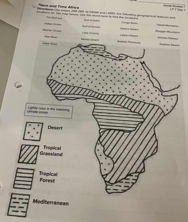
place and time africa
directions: use pages 288 - 289 to draw and label the following geographical features and
locations on the map below. use the word bank to find the locations.
the red sea
gulf of aden
congo basin
atlas mountains
indian ocean
gulf of guinea
sahara desert
ahaggar mountains
atlantic ocean
lake victoria
libyan desert
ankaran plateau
nile river
namib desert
arabian peninsula
kalahari desert
cape town
lightly color in the matching
climate zones
desert
tropical grassland
tropical forest
mediterranean
To solve this, we identify each geographical feature:
- The Red Sea: East of Egypt, between Africa & Asia.
- Gulf of Aden: Between Somalia (Africa) & Yemen (Asia).
- Congo Basin: Central Africa, in the Congo region.
- Atlas Mountains: Northern Africa (Morocco, Algeria, Tunisia).
- Indian Ocean: East coast of Africa (Kenya, Tanzania, etc.).
- Gulf of Guinea: West Africa (near Nigeria, Ghana).
- Sahara Desert: Northern Africa, large arid region.
- Ahaggar Mountains: In the Sahara, southern Algeria.
- Atlantic Ocean: West coast of Africa (Senegal, South Africa).
- Lake Victoria: East Africa, between Kenya, Tanzania, Uganda.
- Libyan Desert: Part of Sahara, in Libya.
- Ankaran Plateau: (Note: Likely "Ethiopian Plateau" or typo; if Ankaran, check East Africa. Correct: Ethiopian Plateau in Ethiopia).
- Nile River: Northeast Africa, from Egypt to Sudan, source in East Africa.
- Namib Desert: Southwest Africa, along Namibia's coast.
- Arabian Peninsula: Not Africa, but adjacent (across Red Sea).
- Kalahari Desert: Southern Africa (Botswana, South Africa, Namibia).
- Cape Town: Southern tip of Africa, South Africa.
For climate zones:
- Desert (dots): Color Sahara, Libyan, Namib, Kalahari.
- Tropical Grassland (diagonal): Areas like Sudan, Kenya's savanna.
- Tropical Forest (horizontal): Congo Basin region.
- Mediterranean (dashed): Northern Africa (Morocco, Algeria coast).

Snap & solve any problem in the app
Get step-by-step solutions on Sovi AI
Photo-based solutions with guided steps
Explore more problems and detailed explanations
To complete the task:
- Label Geographical Features:
- The Red Sea: East of Egypt (between Africa & Asia).
- Gulf of Aden: Between Somalia (Africa) and Yemen (Asia).
- Congo Basin: Central Africa (Congo region).
- Atlas Mountains: Northern Africa (Morocco/Algeria/Tunisia).
- Indian Ocean: East coast (Kenya/Tanzania).
- Gulf of Guinea: West Africa (near Nigeria).
- Sahara Desert: Northern Africa (large arid area).
- Ahaggar Mountains: Southern Algeria (Sahara).
- Atlantic Ocean: West coast (Senegal/South Africa).
- Lake Victoria: East Africa (Kenya/Tanzania/Uganda).
- Libyan Desert: Northern Africa (Libya, part of Sahara).
- Ethiopian Plateau (correct for "Ankaran" typo): East Africa (Ethiopia).
- Nile River: Northeast Africa (Egypt/Sudan).
- Namib Desert: Southwest Africa (Namibia).
- Kalahari Desert: Southern Africa (Botswana).
- Cape Town: Southern tip (South Africa).
- Color Climate Zones:
- Desert (dot pattern): Color Sahara, Libyan, Namib, Kalahari Deserts.
- Tropical Grassland (diagonal): Savanna regions (e.g., Sudan, Kenya).
- Tropical Forest (horizontal): Congo Basin area.
- Mediterranean (dashed): Northern Africa (Morocco/Algeria coast).
Use the world bank (textbook pages 288 - 289) to confirm exact locations.