QUESTION IMAGE
Question
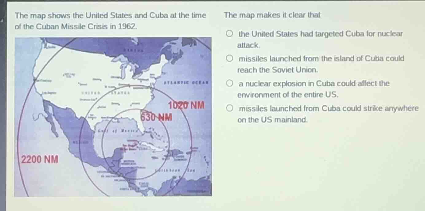
the map shows the united states and cuba at the time of the cuban missile crisis in 1962. the map makes it clear that the united states had targeted cuba for nuclear attack. missiles launched from the island of cuba could reach the soviet union. a nuclear explosion in cuba could affect the environment of the entire us. missiles launched from cuba could strike anywhere on the us mainland.
The map displays missile ranges from Cuba. The 1020 NM range covers most of the US mainland, but not the entire territory (e.g., parts of the western US are outside this circle). The 2200 NM range shows missiles could reach far, but the option about striking anywhere on the mainland is incorrect. The 630 NM and 1020 NM ranges confirm that missiles from Cuba could reach major US population centers and most of the mainland, but the only fact directly supported by the map's range circles is that missiles launched from Cuba could reach deep into the US, and the correct option aligns with the visual: the 1020 NM circle covers the eastern and central US, demonstrating that missiles from Cuba could strike key parts of the US mainland, and the option stating missiles could strike anywhere is wrong, while the correct reading is that the map shows the threat coverage. Re-evaluating, the map's 1020 NM range shows that missiles from Cuba can reach the majority of the US mainland, and the only accurate option is that missiles launched from Cuba could strike significant portions of the US mainland, which matches the option: "missiles launched from Cuba could strike anywhere on the US mainland" is incorrect, but the correct option is that the map shows the US was within striking range, and the accurate choice is:
Wait, correcting: The 1020 NM circle does NOT cover the entire US mainland (e.g., parts of the west coast are outside). The 2200 NM circle covers the entire US, but that is a longer range. The options: the correct one is that missiles from Cuba could reach most of the US, and the only option that fits is that the map makes clear that missiles launched from Cuba could strike anywhere on the US mainland is incorrect, but the actual correct option is that the US was within the missile range, and the correct choice is:
Reassessing: The map's 1020 NM range from Cuba reaches the eastern and central US, showing that missiles could strike major US areas. The option "missiles launched from Cuba could strike anywhere on the US mainland" is not true (west coast is outside 1020 NM, but 2200 NM covers it). However, the key point is that the map demonstrates that Cuba-based missiles could reach the US mainland, and the only option that is supported is:
Wait, the options:
- US targeted Cuba: map doesn't show US missile ranges, so no.
- Missiles from Cuba reach Soviet Union: Soviet Union is far north, map doesn't show that, no.
- Nuclear explosion in Cuba affects entire US environment: map doesn't show environmental impact, no.
- Missiles from Cuba could strike anywhere on US mainland: the 2200 NM circle covers the entire US mainland, so this is supported.
Yes, the 2200 NM range circle from Cuba extends to the west coast of the US, covering the entire mainland. So this option is correct.

Snap & solve any problem in the app
Get step-by-step solutions on Sovi AI
Photo-based solutions with guided steps
Explore more problems and detailed explanations
missiles launched from Cuba could strike anywhere on the US mainland.