QUESTION IMAGE
Question
comprehensive cross - check
what have you learned about latin americas physical, man - made, and political features?
identify the countries, landforms, and bodies of water numbered or lettered on the map.
physical and man - made features
a. __________ e. ________ 1. __________
b. __________ f. ________ 4. __________
c. __________ g. __________
d. __________ h. __________
countries
- __________ 3. ________ 5. __________
- __________ 4. ________ 6. __________
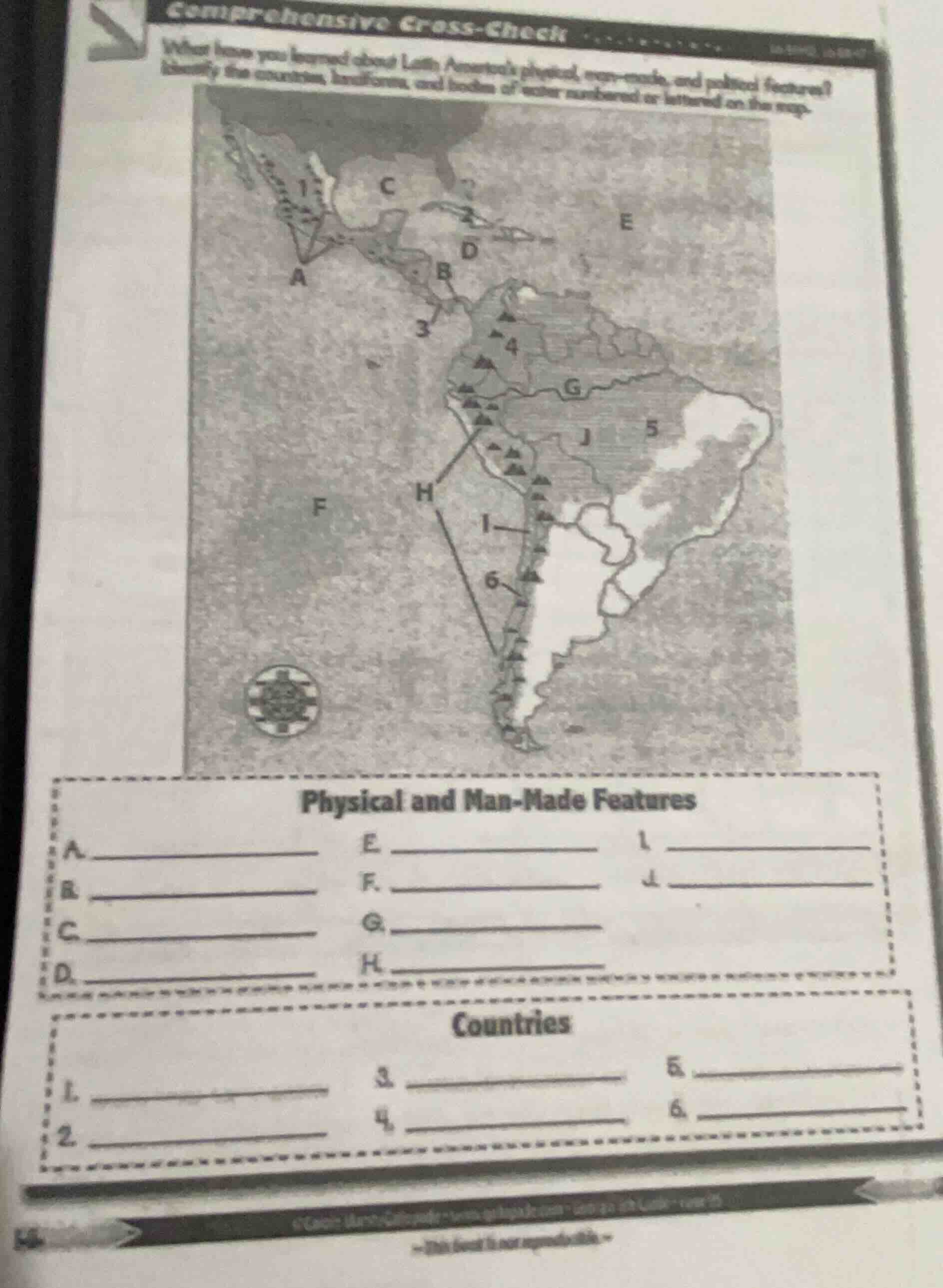
To solve this, we analyze the map of Latin America and identify each labeled feature:
Physical and Man - Made Features
- A: Baja California Peninsula (a physical landform in Mexico).
- B: Panama Canal (a man - made waterway connecting the Atlantic and Pacific).
- C: Gulf of Mexico (a large body of water bordered by several countries).
- D: Caribbean Sea (a sea in the tropics, bordering many Caribbean nations and parts of Central/South America).
- E: Atlantic Ocean (the ocean to the east of Latin America).
- F: Pacific Ocean (the ocean to the west of Latin America).
- G: Amazon River (a major river in South America, with a vast basin).
- H: Andes Mountains (a major mountain range along the western coast of South America).
- I: Rio de la Plata (a river system and estuary in South America).
- J: Brazilian Highlands (a large plateau region in Brazil).
Countries
- 1: Mexico (the large country in North America, part of Latin America).
- 2: Cuba (an island nation in the Caribbean).
- 3: Panama (the country where the Panama Canal is located).
- 4: Peru (a country in western South America, with parts of the Andes and Amazon basin).
- 5: Brazil (the largest country in South America, covering a large portion of the continent).
- 6: Chile (a long, narrow country along the western coast of South America, bordering the Andes and Pacific).
Final Answers (Filling in the Blanks)
Physical and Man - Made Features
A. Baja California Peninsula
B. Panama Canal
C. Gulf of Mexico
D. Caribbean Sea
E. Atlantic Ocean
F. Pacific Ocean
G. Amazon River
H. Andes Mountains
I. Rio de la Plata
J. Brazilian Highlands
Countries
- Mexico
- Cuba
- Panama
- Peru
- Brazil
- Chile

Snap & solve any problem in the app
Get step-by-step solutions on Sovi AI
Photo-based solutions with guided steps
Explore more problems and detailed explanations
To solve this, we analyze the map of Latin America and identify each labeled feature:
Physical and Man - Made Features
- A: Baja California Peninsula (a physical landform in Mexico).
- B: Panama Canal (a man - made waterway connecting the Atlantic and Pacific).
- C: Gulf of Mexico (a large body of water bordered by several countries).
- D: Caribbean Sea (a sea in the tropics, bordering many Caribbean nations and parts of Central/South America).
- E: Atlantic Ocean (the ocean to the east of Latin America).
- F: Pacific Ocean (the ocean to the west of Latin America).
- G: Amazon River (a major river in South America, with a vast basin).
- H: Andes Mountains (a major mountain range along the western coast of South America).
- I: Rio de la Plata (a river system and estuary in South America).
- J: Brazilian Highlands (a large plateau region in Brazil).
Countries
- 1: Mexico (the large country in North America, part of Latin America).
- 2: Cuba (an island nation in the Caribbean).
- 3: Panama (the country where the Panama Canal is located).
- 4: Peru (a country in western South America, with parts of the Andes and Amazon basin).
- 5: Brazil (the largest country in South America, covering a large portion of the continent).
- 6: Chile (a long, narrow country along the western coast of South America, bordering the Andes and Pacific).
Final Answers (Filling in the Blanks)
Physical and Man - Made Features
A. Baja California Peninsula
B. Panama Canal
C. Gulf of Mexico
D. Caribbean Sea
E. Atlantic Ocean
F. Pacific Ocean
G. Amazon River
H. Andes Mountains
I. Rio de la Plata
J. Brazilian Highlands
Countries
- Mexico
- Cuba
- Panama
- Peru
- Brazil
- Chile