QUESTION IMAGE
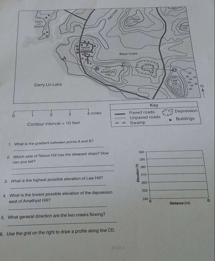
Question
contour interval = 10 feet
key
paved roads
depression
unpaved roads
buildings
swamp
- what is the gradient between points a and b?
- which side of nasus hill has the steepest slope? how can you tell?
- what is the highest possible elevation of law hill?
- what is the lowest possible elevation of the depression east of amethyst hill?
- what general direction are the two creeks flowing?
- use the grid on the right to draw a profile along line cd.
(the chart on the right has elevation (m) from 240 to 300 and distance (m) with points c and d.)
1. Gradient between A and B
Step1: Find elevation difference
Point A is on 250 ft contour, Point B is on 270 ft contour (since contour interval is 10, 250 + 2*10 = 270). Difference: \( 270 - 250 = 20 \) ft.
Step2: Find horizontal distance
Using scale, A to B is 1 mile (1 mile = 5280 ft).
Step3: Calculate gradient
Gradient = \( \frac{\text{elevation change}}{\text{horizontal distance}} = \frac{20}{5280} \approx 0.0038 \) (or \( \frac{20}{1} = 20 \) ft/mile).
The steepest slope has the closest contour lines. The northwest side of Nasus Hill (near Red Creek) has contour lines closer together, indicating a steeper slope.
Step1: Identify contour interval
Contour interval is 10 ft. The highest contour around Law Hill is 310 ft (since it's a hill, the next contour would be 310, but the peak is less than 310 + 10 = 320? Wait, Law Hill's highest contour is 310? Wait, the innermost contour is 300, then 310? Wait, no, the key: Law Hill has contours. Wait, the contour interval is 10. The highest contour shown is 300? Wait, no, the map: Law Hill's innermost contour is, let's see, the depression is 250, Law Hill has more contours. Wait, the highest possible elevation is just below the next contour. If the innermost contour is 310 (assuming), but wait, the contour interval is 10. So if the last contour is 310, the highest possible is less than 310 + 10 = 320? Wait, no, Law Hill: the innermost contour is, let's check the map. Wait, the problem: Law Hill's highest contour—wait, the contour lines around Law Hill: the outermost is 300, then 310, 320? Wait, no, the contour interval is 10. So the highest possible elevation is less than (highest contour + contour interval). If the highest contour is 310, then highest possible is < 320, but wait, maybe the innermost is 310? Wait, no, the map: Law Hill has a peak. Wait, the correct way: the highest contour line on Law Hill is, say, 310, so the highest elevation is less than 310 + 10 = 320? Wait, no, maybe the innermost contour is 310, so the peak is between 310 and 320? Wait, no, the contour interval is 10. So the highest possible elevation is 319 feet (since it must be less than 320, as the next contour would be 320, but it's a hill, so the peak is less than 320, and at least 310 + 10? Wait, no, confusion. Wait, the highest contour line on Law Hill: let's see the map. The key: Law Hill is a hill, so the innermost contour is the highest. Let's assume the innermost contour is 310, so the highest elevation is less than 310 + 10 = 320, so maximum possible is 319 feet (since it can't reach 320, as that would be a new contour).

Snap & solve any problem in the app
Get step-by-step solutions on Sovi AI
Photo-based solutions with guided steps
Explore more problems and detailed explanations
The gradient is \( \frac{20 \text{ feet}}{1 \text{ mile}} \) (or approximately 0.0038 ft/ft).