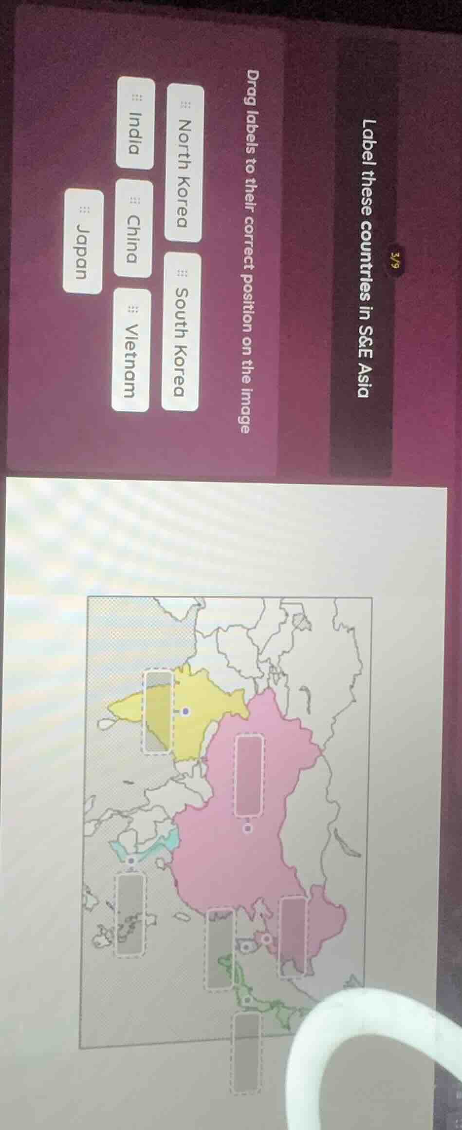
QUESTION IMAGE
Question
label these countries in s&e asia
drag labels to their correct position on the image
north korea
south korea
india
china
vietnam
japan
To label the countries in S&E (Southeast and East) Asia:
- The yellow - colored region near the Korean Peninsula (upper left) should be labeled "North Korea" or "South Korea". Given the position, the yellow area is likely North Korea or South Korea. The large pink landmass is "China". The island - like area to the east (left - most island - related label spot) is "Japan". The area to the south of China (among the lower labels) would be "Vietnam", the area to the southwest (large sub - continental area) is "India", and the other Korean - like area (if the first yellow is North Korea, the adjacent could be South Korea).
Let's match each label:
- The yellow region (upper left, near the sea, Korean - like): North Korea or South Korea. Let's assume the upper - most yellow is North Korea, and the adjacent (if any) is South Korea. But looking at the labels, the first (top - most) label spot (yellow) can be "North Korea" or "South Korea". The large pink is "China". The left - most island (Japan's position) is "Japan". The area to the south of China (Vietnam's position) is "Vietnam". The large sub - continent (India's position) is "India". The other Korean (if the first is North, the other is South) is "South Korea".
Let's do the drag - and - drop logic:
- The yellow region (first label spot): North Korea (or South Korea, but typically North Korea is more north - oriented in such maps).
- The large pink: China.
- The left - most island: Japan.
- The area to the south of China (lower middle - south): Vietnam.
- The large sub - continent (southwest): India.
- The other Korean (adjacent to North Korea, if North is first): South Korea.

Snap & solve any problem in the app
Get step-by-step solutions on Sovi AI
Photo-based solutions with guided steps
Explore more problems and detailed explanations
- Yellow region (top - most label spot): North Korea
- Large pink region: China
- Left - most island - like label spot: Japan
- Lower middle - south label spot (below China): Vietnam
- Southwest large sub - continental label spot: India
- Label spot adjacent to North Korea (if North Korea is placed): South Korea
(Note: The exact mapping depends on the map's layout, but the general geographic positions are: Japan is an island to the east, China is the large mainland, India is the sub - continent to the southwest, Vietnam is in Southeast Asia (south of China), North and South Korea are on the Korean Peninsula, with North Korea more north - oriented and South Korea to the south of North Korea on the peninsula.)