QUESTION IMAGE
Question
name
class
date
chapter 1 the power of geography: geographic thinking
unpacking frqs: steps and strategies
national
geographic
learning
step 1 review the frq prompt and any stimuli carefully.
an frq can be a written prompt, a written prompt with one stimulus, or a written prompt with
two stimuli. in written prompts, watch for the task verbs compare, define, describe, explain,
and identify. these verbs will tell you how to respond. in frqs with stimuli, review the data,
images, or maps carefully, looking for geographic patterns, relationships, and outcomes.
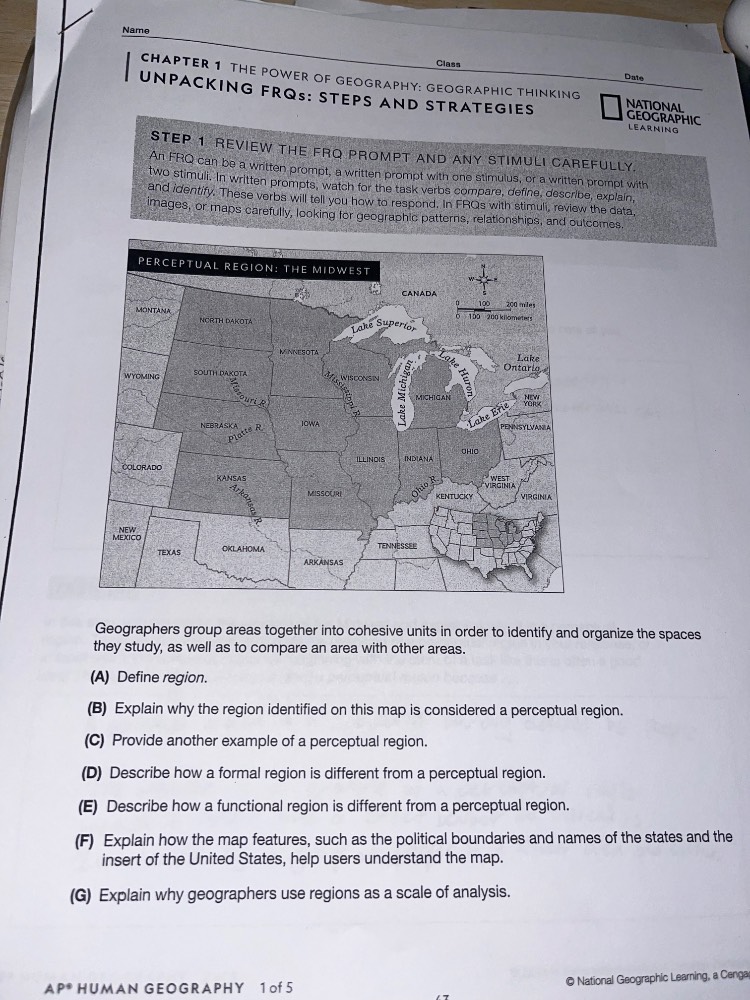
perceptual region: the midwest
canada
100 200 miles
0 160 320 kilometers
geographers group areas together into cohesive units in order to identify and organize the spaces
they study, as well as to compare an area with other areas.
(a) define region.
(b) explain why the region identified on this map is considered a perceptual region.
(c) provide another example of a perceptual region.
(d) describe how a formal region is different from a perceptual region.
(e) describe how a functional region is different from a perceptual region.
(f) explain how the map features, such as the political boundaries and names of the states and the
insert of the united states, help users understand the map.
(g) explain why geographers use regions as a scale of analysis.
ap human geography 1 of 5
© national geographic learning, a cengage
(A) Defined the core term using standard geographic language focused on shared traits and distinct area.
(B) Linked the Midwest to the key trait of perceptual regions: subjective, perception-based boundaries tied to culture/history.
(C) Selected a widely recognized perceptual region with similar subjective boundary traits to the Midwest.
(D) Contrasted formal regions' objective, measurable boundaries with perceptual regions' subjective ones.
(E) Distinguished functional regions' central node/interaction focus from perceptual regions' perception-based identity.
(F) Explained how map elements (state borders, inset) clarify the region's location and scope for users.
(G) Outlined the practical analytical purpose of regions: simplifying data, identifying spatial patterns, and enabling scaled analysis.

Snap & solve any problem in the app
Get step-by-step solutions on Sovi AI
Photo-based solutions with guided steps
Explore more problems and detailed explanations
(A) A region is a distinct area with shared characteristics.
(B) The Midwest is a perceptual region because its boundaries and definition are based on shared cultural, social, and historical perceptions rather than strict, objective criteria; people's ideas of what constitutes the Midwest vary slightly.
(C) The American South is another example of a perceptual region.
(D) A formal region has clear, objective boundaries defined by uniform measurable traits (e.g., a country with set political borders, or a climate zone with consistent temperature/precipitation patterns), while a perceptual region's boundaries are subjective and based on people's perceptions.
(E) A functional region is defined by a central node and the surrounding area that interacts with it (e.g., a city's metropolitan area where people commute to the central city for work), while a perceptual region is based on shared cultural or social perceptions with no single central functional hub.
(F) The political boundaries and state names clearly demarcate the specific states commonly associated with the perceptual Midwest, making the region's general geographic scope concrete. The U.S. inset map provides a national context, showing where the Midwest is located relative to the rest of the country, helping users situate the region spatially.
(G) Regions allow geographers to simplify complex spatial data, identify patterns and similarities/differences across areas, and analyze how geographic factors (culture, environment, economy) operate at a manageable, meaningful scale rather than studying the entire world at once.