QUESTION IMAGE
Question
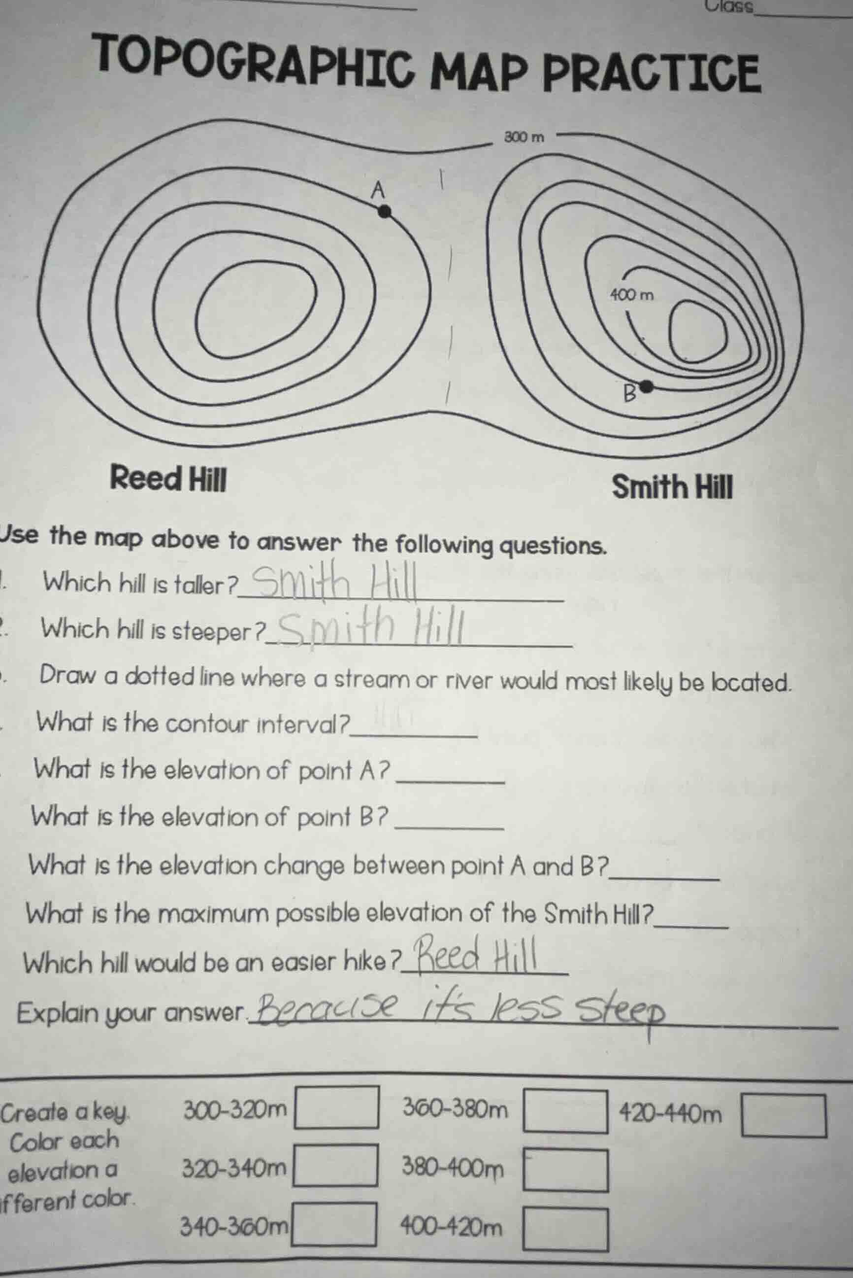
topographic map practice
use the map above to answer the following questions.
- which hill is taller?
- which hill is steeper?
- draw a dotted line where a stream or river would most likely be located.
- what is the contour interval?
- what is the elevation of point a?
- what is the elevation of point b?
- what is the elevation change between point a and b?
- what is the maximum possible elevation of the smith hill?
- which hill would be an easier hike?
- explain your answer.
create a key. color each elevation a different color.
300-320m
320-340m
340-360m
360-380m
380-400m
400-420m
420-440m
Step1: Find contour interval
The outermost contour is 300 m, and the labeled contour on Smith Hill is 400 m. Count the intervals between them: from 300 m to 400 m, there are 5 contour lines in between, so the interval is $\frac{400-300}{5}=20$ m.
Step2: Find elevation of Point A
Point A is on the first contour inside 300 m, so $300 + 20 = 320$ m.
Step3: Find elevation of Point B
Point B is on the first contour inside 400 m, so $400 + 20 = 420$ m.
Step4: Calculate elevation change
Subtract A's elevation from B's: $420 - 320 = 100$ m.
Step5: Find max elevation of Smith Hill
The highest labeled contour is 400 m, add one interval and subtract 1 m: $400 + 20 + 20 - 1 = 439$ m.
Step6: Locate stream
Streams form in low areas (saddles) between hills; draw a dotted line through the narrow depression between Reed Hill and Smith Hill.

Snap & solve any problem in the app
Get step-by-step solutions on Sovi AI
Photo-based solutions with guided steps
Explore more problems and detailed explanations
- Which hill is taller? Smith Hill
- Which hill is steeper? Smith Hill
- (Draw a dotted line through the low, narrow saddle area between Reed Hill and Smith Hill)
- What is the contour interval? 20 m
- What is the elevation of point A? 320 m
- What is the elevation of point B? 420 m
- What is the elevation change between point A and B? 100 m
- What is the maximum possible elevation of the Smith Hill? 439 m
- Which hill would be an easier hike? Reed Hill
- Explain your answer: Because it's less steep
- (For the color key: Assign a unique color to each elevation range, e.g., 300-320m: light blue, 320-340m: blue, 340-360m: dark blue, 360-380m: light green, 380-400m: green, 400-420m: dark green, 420-440m: brown)