QUESTION IMAGE
Question
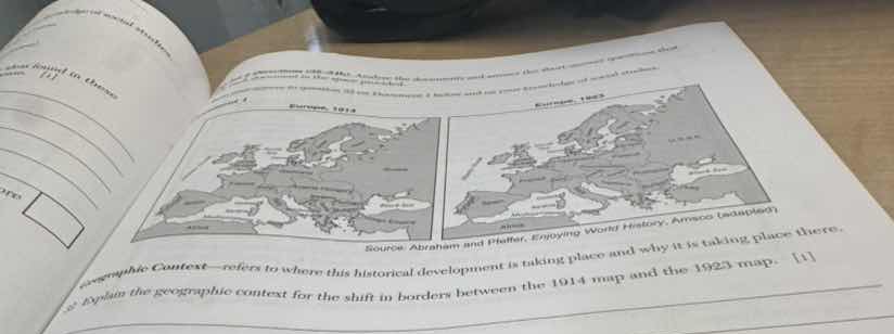
source: abraham and helffer, enjoying world history, amsco (adapted)
geographic context—refers to where this historical development is taking place and why it is taking place there.
explain the geographic context for the shift in borders between the 1914 map and the 1923 map. 1
The maps are from 1914 (pre - WWI) and 1923 (post - WWI). WWI led to the Treaty of Versailles, which redrew Europe's borders. The collapse of empires (like Austro - Hungarian, Ottoman, Russian) and the creation of new nations (e.g., Czechoslovakia, Yugoslavia, Poland's re - establishment) caused the border shift. The geographic context includes the war's impact on territorial control, ethnic self - determination, and the dissolution of old imperial systems.

Snap & solve any problem in the app
Get step-by-step solutions on Sovi AI
Photo-based solutions with guided steps
Explore more problems and detailed explanations
The geographic context of the border shift between the 1914 and 1923 maps is rooted in World War I (WWI) and its aftermath. In 1914, Europe had imperial - era borders (e.g., Austro - Hungarian Empire, Russian Empire - controlled areas). WWI led to the defeat of Central Powers (Germany, Austria - Hungary, Ottoman Empire) and the collapse of empires (Austro - Hungarian, Ottoman, Russian). The Treaty of Versailles (1919) and related agreements redrew borders based on ethnic self - determination, creating new nations (e.g., Czechoslovakia, Yugoslavia, re - established Poland) and adjusting Germany’s borders (e.g., loss of Alsace - Lorraine, creation of the Polish Corridor). The dissolution of old imperial systems, post - war territorial settlements, and ethnic/nationalist movements drove the border changes.