QUESTION IMAGE
Question
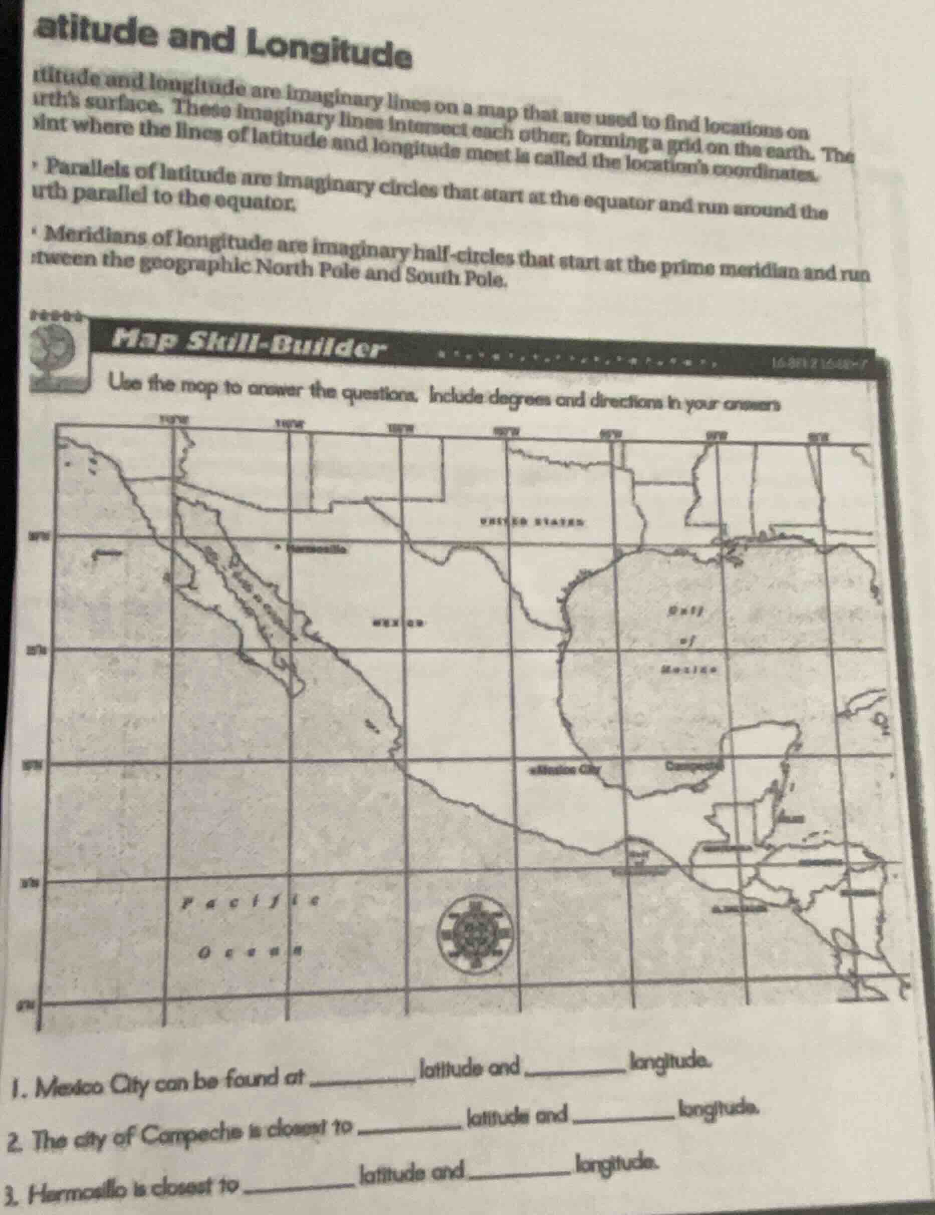
atitude and longitude
ltitude and longitude are imaginary lines on a map that are used to find locations on
earth’s surface. these imaginary lines intersect each other, forming a grid on the earth. the
point where the lines of latitude and longitude meet is called the location’s coordinates.
- parallels of latitude are imaginary circles that start at the equator and run around the
earth parallel to the equator.
- meridians of longitude are imaginary half - circles that start at the prime meridian and run
between the geographic north pole and south pole.
map skill - builder
use the map to answer the questions. include degrees and directions in your answers
- mexico city can be found at ____ latitude and ____ longitude.
- the city of campeche is closest to ____ latitude and ____ longitude.
- hermosillo is closest to ____ latitude and ____ longitude.
To solve these latitude and longitude problems, we analyze the map:
1. Mexico City
- Latitude: Find the horizontal (latitude) line Mexico City lies on. From the map, it’s near \( 19^\circ \text{N} \) (north of the equator, so positive latitude).
- Longitude: Find the vertical (longitude) line. Mexico City is near \( 99^\circ \text{W} \) (west of the prime meridian, so negative longitude, but labeled as \( 99^\circ \text{W} \)).
2. Campeche
- Latitude: Campeche is near \( 19^\circ \text{N} \) (or slightly adjusted, but the closest grid line is \( 19^\circ \text{N} \)).
- Longitude: It’s near \( 90^\circ \text{W} \) (west of prime meridian).
3. Hermosillo
- Latitude: Hermosillo is near \( 30^\circ \text{N} \) (north of equator).
- Longitude: It’s near \( 110^\circ \text{W} \) (west of prime meridian).
Final Answers (Sample, based on map grid):
- Mexico City: \( \boldsymbol{19^\circ \text{N}} \) latitude, \( \boldsymbol{99^\circ \text{W}} \) longitude.
- Campeche: \( \boldsymbol{19^\circ \text{N}} \) latitude, \( \boldsymbol{90^\circ \text{W}} \) longitude.
- Hermosillo: \( \boldsymbol{30^\circ \text{N}} \) latitude, \( \boldsymbol{110^\circ \text{W}} \) longitude.
(Note: Exact values depend on the map’s grid spacing; adjust if the map has finer increments.)

Snap & solve any problem in the app
Get step-by-step solutions on Sovi AI
Photo-based solutions with guided steps
Explore more problems and detailed explanations
To solve these latitude and longitude problems, we analyze the map:
1. Mexico City
- Latitude: Find the horizontal (latitude) line Mexico City lies on. From the map, it’s near \( 19^\circ \text{N} \) (north of the equator, so positive latitude).
- Longitude: Find the vertical (longitude) line. Mexico City is near \( 99^\circ \text{W} \) (west of the prime meridian, so negative longitude, but labeled as \( 99^\circ \text{W} \)).
2. Campeche
- Latitude: Campeche is near \( 19^\circ \text{N} \) (or slightly adjusted, but the closest grid line is \( 19^\circ \text{N} \)).
- Longitude: It’s near \( 90^\circ \text{W} \) (west of prime meridian).
3. Hermosillo
- Latitude: Hermosillo is near \( 30^\circ \text{N} \) (north of equator).
- Longitude: It’s near \( 110^\circ \text{W} \) (west of prime meridian).
Final Answers (Sample, based on map grid):
- Mexico City: \( \boldsymbol{19^\circ \text{N}} \) latitude, \( \boldsymbol{99^\circ \text{W}} \) longitude.
- Campeche: \( \boldsymbol{19^\circ \text{N}} \) latitude, \( \boldsymbol{90^\circ \text{W}} \) longitude.
- Hermosillo: \( \boldsymbol{30^\circ \text{N}} \) latitude, \( \boldsymbol{110^\circ \text{W}} \) longitude.
(Note: Exact values depend on the map’s grid spacing; adjust if the map has finer increments.)